As part of the research for the project Virtuelle Mauer/ReConstructing the Wall we looked at three sites along the former the Berlin Wall, examining how the presence of the Wall affected the environment of the site, its urban development, and the life of the people living on both sides of the Wall. Each of these densely populated inner city quarters, cut in half by the Death Strip, developed their own individual cultures "in the shadow of the Wall" and presented us with engaging dramatic potential.
On the basis of our research, we decided to concentrate on the area between Heinrich-Heine-Strasse and the Schilling Bridge, described on the main page of the "Site" link. The other two sites, Lohmuehlen Bruecke and Oderberger Strasse, are described here with links to further information.
- Lohmuehlen
Bruecke [ map ]
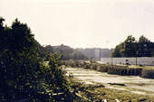
In the area around the Lohmuehlen Bridge, a canal formed the border between Treptow and the West German quarters of Kreuzberg and Neukoelln. The Death Strip cut across several bridges and then zigzagged down narrow residential streets. In places residents on East and West could look across the Death Strip directly into each others' living rooms.
- Oderberger
Strasse [ map ]
The intersection of Oderberger, Schwedter, Bernauer and Eberswalder Streets was one of the few places in East Berlin where the Wall itself was visible from a normal residential area. (Most residential areas on the East German side of the Wall were restricted zones that could only be entered with express permission of the authorities.) Here the Wall separated West Berlin from the Prenzlauer Berg district, the center of the underground artistic and political opposition scene in East Berlin.
[ << back to main page for "Site" ]
| Home |
| Introduction |
| > Site |
| Development |
| Presentation |
| Documentation |
| Artist Team T+T |
| Supporters |
| Berlin Wall Links |
| Events |